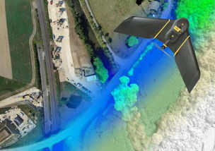
EBee Plus Drone Overview

The innovation and change of eBee plus drones, close to human hand throwing, breaking the traditional unmanned aircraft operation mode, redefining high-end fixed-wing drones. In order to meet the needs of different missions, eBee plus has a flight time of up to fifty-nine minutes. It has a professional flight control system that can be used with various loads. It can also be upgraded to the RTK / PPK version to reduce the deployment of ground image control points.
 1. Parameters
A) Hardware
Wingspan: 110cm
Weight: 1.1kg
Motor: low noise, brushless, electric
Radio communication range: 3km (up to 8km)
Wing: removable
Sensor (standard): sensefly S.O.D.A camera
Sensor (optional): Parrot Sepuoia multi-spectral camera, thermoMAP thermal infrared camera
(2) Software
Flight planning and control software (standard): eMotion
Image processing software (optional): Pix4Dmapper
(3) Control
Hand toss takeoff, automatic 3D flight planning
Cruising speed: 40km / h-110km / h (11m / s-30m / s)
Wind resistance: up to 45km / h (level 6 wind)
Maximum flight time: 59min
Automatic landing: straight-line landing, 5m error range
Ground control point: not required to activate RTK / PPK, required for inactive version
(4) Results
Flight area: 2.2 square kilometers (flight altitude 120m)
The widest flight area: 40 square kilometers
Ground sampling interval: up to 1cm / pixel
X, Y, Z absolute accuracy (activate RTK / PPK): up to 3cm / 5cm
X, Y, Z absolute accuracy (RTK / PPK not activated): 1m-5m
(5) Camera (S.O.D.A. camera)
Sensor category: RGB (20 million pixels)
Sensor size: 1 inch (optical format)
Pixel pitch: 2.33 microns
Shutter: Global shutter
Ground sampling interval: 2.9cm / pixel (122m flying height)
Dustproof and shockproof: Yes
1. Parameters
A) Hardware
Wingspan: 110cm
Weight: 1.1kg
Motor: low noise, brushless, electric
Radio communication range: 3km (up to 8km)
Wing: removable
Sensor (standard): sensefly S.O.D.A camera
Sensor (optional): Parrot Sepuoia multi-spectral camera, thermoMAP thermal infrared camera
(2) Software
Flight planning and control software (standard): eMotion
Image processing software (optional): Pix4Dmapper
(3) Control
Hand toss takeoff, automatic 3D flight planning
Cruising speed: 40km / h-110km / h (11m / s-30m / s)
Wind resistance: up to 45km / h (level 6 wind)
Maximum flight time: 59min
Automatic landing: straight-line landing, 5m error range
Ground control point: not required to activate RTK / PPK, required for inactive version
(4) Results
Flight area: 2.2 square kilometers (flight altitude 120m)
The widest flight area: 40 square kilometers
Ground sampling interval: up to 1cm / pixel
X, Y, Z absolute accuracy (activate RTK / PPK): up to 3cm / 5cm
X, Y, Z absolute accuracy (RTK / PPK not activated): 1m-5m
(5) Camera (S.O.D.A. camera)
Sensor category: RGB (20 million pixels)
Sensor size: 1 inch (optical format)
Pixel pitch: 2.33 microns
Shutter: Global shutter
Ground sampling interval: 2.9cm / pixel (122m flying height)
Dustproof and shockproof: Yes
 2. Main features
High efficiency-flight time: 59 minutes; flight area at 122 meters altitude: 2.2 square kilometers
High precision-Made in Switzerland, built-in RTK and PPK, activated and switched at any time; the absolute accuracy of orthophoto and digital surface model can reach 3 cm; high-precision results in arbitrary terrain
Convenient and fast flight control software eMotion3-users can formulate overall flight planning and multi-voyage flight for the project; multi-area flight missions can be formulated in one plan; the 3D real scene configured by itself allows you to plan, simulate and control more accurately Man-machine track
Equipped with a variety of loads that are perfectly suitable for the project-professional RGB camera: measurement / geographic information; thermal infrared camera: photovoltaic / rescue / environmental protection; multi-spectral camera: agriculture / forestry / cultural relics protection
2. Main features
High efficiency-flight time: 59 minutes; flight area at 122 meters altitude: 2.2 square kilometers
High precision-Made in Switzerland, built-in RTK and PPK, activated and switched at any time; the absolute accuracy of orthophoto and digital surface model can reach 3 cm; high-precision results in arbitrary terrain
Convenient and fast flight control software eMotion3-users can formulate overall flight planning and multi-voyage flight for the project; multi-area flight missions can be formulated in one plan; the 3D real scene configured by itself allows you to plan, simulate and control more accurately Man-machine track
Equipped with a variety of loads that are perfectly suitable for the project-professional RGB camera: measurement / geographic information; thermal infrared camera: photovoltaic / rescue / environmental protection; multi-spectral camera: agriculture / forestry / cultural relics protection
 3. Main hardware
The eBee plus fuselage has a wingspan of about 110cm, a take-off weight of less than 1.1kg, and the wings are removable. Adopt highly integrated and air transport box design, very suitable for individual soldier combat, portable and efficient.
Propulsion: Brushless engine.
Battery: High-performance polymer lithium battery, 59min high-efficiency battery life (not affected by wind), plug-in design, charging time <90min.
Built-in autopilot, gyroscope, GPS, etc., to monitor the wing, maintain flight status and return attitude.
Antenna: Connect the route planning software through 2.4G wireless communication antenna.
Sensors: Real-time detection of airspeed, wind speed and flight altitude.
Status indicator: The indicator shows the current status, ensuring that the operator has the real-time status of the aircraft.
Ground height sensor: It consists of a high-speed optical sensor and a lens device. It is used to detect the proximity of the aircraft to the ground, which can avoid damage to the aircraft near the ground during flight. It can also assist in landing and make landing more accurate.
Propeller: The propeller is connected with elastic materials to avoid damage to the engine due to the landing of the propeller and extend the service life of the engine.
Flight speed: 40km / h ~ 110km / h (11m / s-30m / s)
Flight conditions: up to 45km / h (12m / s) wind resistance.
3. Main hardware
The eBee plus fuselage has a wingspan of about 110cm, a take-off weight of less than 1.1kg, and the wings are removable. Adopt highly integrated and air transport box design, very suitable for individual soldier combat, portable and efficient.
Propulsion: Brushless engine.
Battery: High-performance polymer lithium battery, 59min high-efficiency battery life (not affected by wind), plug-in design, charging time <90min.
Built-in autopilot, gyroscope, GPS, etc., to monitor the wing, maintain flight status and return attitude.
Antenna: Connect the route planning software through 2.4G wireless communication antenna.
Sensors: Real-time detection of airspeed, wind speed and flight altitude.
Status indicator: The indicator shows the current status, ensuring that the operator has the real-time status of the aircraft.
Ground height sensor: It consists of a high-speed optical sensor and a lens device. It is used to detect the proximity of the aircraft to the ground, which can avoid damage to the aircraft near the ground during flight. It can also assist in landing and make landing more accurate.
Propeller: The propeller is connected with elastic materials to avoid damage to the engine due to the landing of the propeller and extend the service life of the engine.
Flight speed: 40km / h ~ 110km / h (11m / s-30m / s)
Flight conditions: up to 45km / h (12m / s) wind resistance.
 The fuselage is equipped with RTK and PPK equipment, which can be upgraded for a fee to solve the worries of buying drones again. (Available after payment upgrade)
High-definition / thermal infrared / multi-spectral sensors: eBee plus is equipped with a 20-megapixel S.O.D.A high-definition camera, and can be arbitrarily matched with other thermal infrared or multi-spectral cameras, which can be used in different industries
Nimbus VTOL For Mapping and Survey

Version: Nimbus VTOL
Wingspan: 1800mm
Length: 1300mm
Suggested Take-off Weight: 6kg
Suggested Payload: 800g
Total Weight: 3.36kg(no battery)
Max. Flying Height: 3500m
Max. Flying Speed: 35m/s
Average Speed: 15m/s to 16m/s
Stall Speed: 10m/s to 11m/s
Max Wind Resistance: ≤10.7m/s
Mapping Accuracy: Centimeter
Suggested Battery: 6S 12000mah Lipo Battery;
 PREVIOUS:How To Distinguish Drone Helicopter and Rotorcraft
NEXT:Hybrid power allows drones to fly farther
PREVIOUS:How To Distinguish Drone Helicopter and Rotorcraft
NEXT:Hybrid power allows drones to fly farther
