How to price drone services to stay both competitive and profitable
If you are a new drone service provider trying to figure out your place in this landscape, the question of pricing is likely top of mind.
How do I make drone for agriculture and commercial price to stay both competitive and profitable? To help new drone businesses get a sense of what other drone service providers are charging, below is the reaserch by DroneDeploy Drone Mapping Directory and our friends at Airstoc, and also they spent time talking with established drone service providers about the nuances of pricing
Factors that Affect Pricing of Drone Services
When it comes to pricing drone services, Most drone businesses we spoke to said that they begin with a per-hour rate that will allow them to remain profitable and then adjust that rate up or down depending on a number of elements. Some variables that affect rates include:
Travel surcharges: Is a job outside of your regular service area?
Insurance coverage: Do your clients require you to carry a large liability policy?
Industry: What industry do you work with, and what are the price points in that industry?
Deliverables and quality: What maps or models do you provide your clients?
Level of expertise: Do you have a special license or certification such as a professional engineer or licensed surveyor?
Pricing-per-acre: For your industry, is it better to charge per-acre instead of per-hour?
Market value and ROI: What problems do your services solve and how much is that worth to your clients?
So what do all of these considerations mean in the real world of drone mapping? Here’s what the drone mapping providers we spoke to had to say about the finer points of pricing:
Travel Surcharges
While some amount of travel is just a part of doing business, there is a point at which excess mileage and travel time should be factored into pricing. Based on the data we looked at, pilots that serve a larger area tend to charge higher hourly rates to accommodate for the extra time spent on the road, of course this fee is waives if the client arranges travel, such as a flight and satisfactory board and lodging.
Insurance Coverage and Industry Type
Liability insurance is a must-have for drone service providers. A typical insurance policy provides one million dollars of coverage. However, certain industries, such as mining, require drone pilots to carry larger policies, and pilots typically charge higher hourly rates to offset this increased cost. for example in the landfill industry, subcontractors are often required to carry as much as a $4 million umbrella liability policy. This is one factor that comes into play sets the prices.
Deliverables and Quality
At the end of the day, deliverables are what matter most to a client, and pricing reflects this. Because of the level of data they are able to give to their clients, drone pilots who provide mapping services already charge an average of $23 more per hour than regular commercial drone pilots. Within those mapping services, price point is further affected by the specific deliverables a client requests, as well as the quality of those deliverables.
Phil Myers of Toledo Aerial Media says his standard deliverables are an orthomosaic map and that same map in JPEG form. He then charges additional fees for NDVI and thermal mapping. Likewise, many drone service providers charge extra for providing 3D models, as well as for further processing the data using software like ArcGIS.
Pricing should reflect not only the deliverables a drone business provides, the quality of those deliverables. Pricing should reflect your expertise, such as photography experience that will help you do post-processing work on your images. This is also evidenced by the fact that hourly rates tend to vary based on additional certifications held by drone service providers.
Pricing Per Acre
Some drone service providers working in the agricultural industry, find it is more straightforward to set prices on a per-acre basis, as opposed to per-hour. Another commercial pilot serving the agriculture area took a similar approach:
“I have calculated rates dependent upon area size. These rates take into account the equipment that is required to fly, the man hours spent on all the prep work and actual flight ops, and processing time for both man hours and electricity.”
The same service provider also added that he often gives per-acre discounts for large, single-area projects, because the utilization and efficiency goes up. However, this discount only applies for continuous sections of land, not in cases where the total area mapped is spread out into smaller, disconnected patches.
Market Value and Return-on-Investment for Clients
Andrew Cutter, who has an IT background and now maps for the agriculture industry, also takes the current market value for a particular crop into consideration when he sets the price for each particular job. “The [per-acre] rate is determined by crop,” he says. “I have to factor in what a bushel of corn or soybean is bringing in currently.” In other words, how much are his services worth to a client? If a farmer wants Andrew to provide a crop health map of his fields so that he can detect a pest infestation, that map has the potential to save the farmer a large amount of money, especially if it helps him catch an infestation early. The higher the price of the crop, the higher the farmer’s return-on-investment for purchasing those mapping services.
Total Time Spent
All of the factors listed above are simply a framework to help guide drone service providers toward profitability. Justin Moore of Aerial Airborne Photography reminds new businesses that, as basic as it sounds, it’s also important to remember to accommodate your time into your pricing model. This includes everything — from travel, to onsite time, to the time it takes to process the data and prepare the deliverables. Those small bits of extra time spent on tasks can be easy to overlook, but if you don’t accommodate for them, says Justin, “you’ll look at your price and how much time you spent on it, and you might be working for less than minimum wage.”

The Benefits of Pro Bono Projects
Justin Moore, who maps commercially for the real estate development sector and has also done pro bono work for several environmental conservation projects, finds great value in taking pro bono work because it allows him to be, as he puts it, a “drone ambassador,” advancing the reputation of the drone community. Says Justin, “If there’s no local understanding about what drones can do for the community, your business model is immediately threatened.”
But taking pro bono work has also been good for Justin’s bottom line. Not only has it given him the chance to gain experience, but it has also attracted new, paying business. In fact, one of his biggest real estate development clients came through word-of-mouth referral from a pro bono job.
Pricing Data
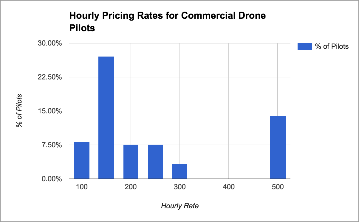
As promised, here is the data we uncovered about how commercial drone pilots are pricing various services. First, we took a look at Airstoc’s survey of 700 US-based commercial drone pilots:
Hourly Pricing Rates for Commercial Drone Pilots
Airstoc’s survey gives a great overview of the industry as a whole, but we also wanted to dig into pricing specifically as it applies to mapping. For this, we analyzed data from over 200 DroneDeploy users in our Drone Mapping Directory. Here’s what we found:
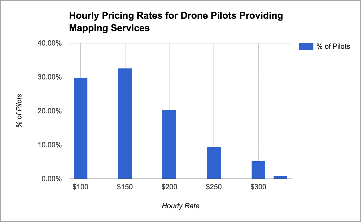
Compared to the overview data provided by Airstoc, we found that on average drone service providers specializing in mapping are able to charge higher rates.
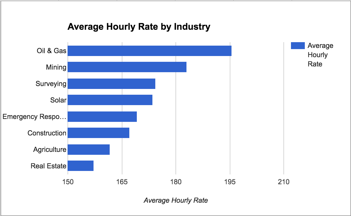
The data shows that the industry serviced plays a role in determining the hourly rate.

The data shows that hourly rates tend to increase with the distance service providers must travel in order to serve customers.

When comparing certifications, we see that those service providers with specialized certifications in fields such as agronomy, GIS and real estate are able to collect a higher median hourly rate than those without a certification.
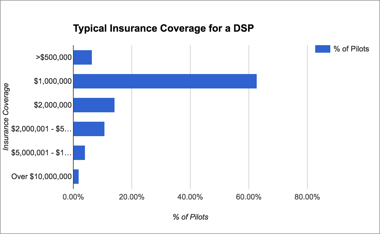
The overwhelming majority of service providers typically opt for a million dollars in coverage or more to protect themselves from liability on job sites.

Service providers operating with a higher amount of liability coverage are likely working in industries or within use cases where they are able to charge more for their services due to market demand, specialization and risk of damage.
Whether you are providing commercial drone services full time, or just beginning to consider opening a drone business, determining the right price point for your location and specific market is the key to profitability. Take stock of the time a job requires from flight to finished product, factor in elements like travel and insurance and gather market information for your particular location. Price your deliverables, as well as their quality, accordingly. And, as with any business endeavor, continually re-evaluate your pricing model to make sure you stay competitive and profitable in the ever-changing world of the commercial drone industry.
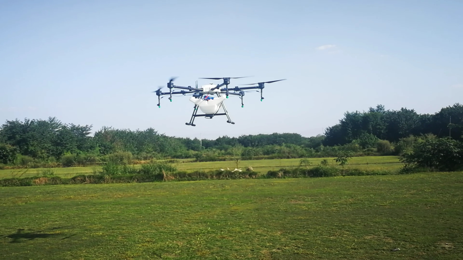
6 rotors plant protection UAV 16KGS agriculture sprayer
Intelligent Agriculture is the trend of all over the world. And the intelligent drone act as a important role in this world plan.
Agriculture spraying drone can replace the traditional pesticide sprayer and it's speed is 40times of the traditional sprayer. It will save 90% water and 30%-40% pesticide. Small droplet diameter make the pesticide more well-distribute and improve the effect. At the same time, it will make the people faraway from the pesticide and reduce the pesticide remain of the crop.
