
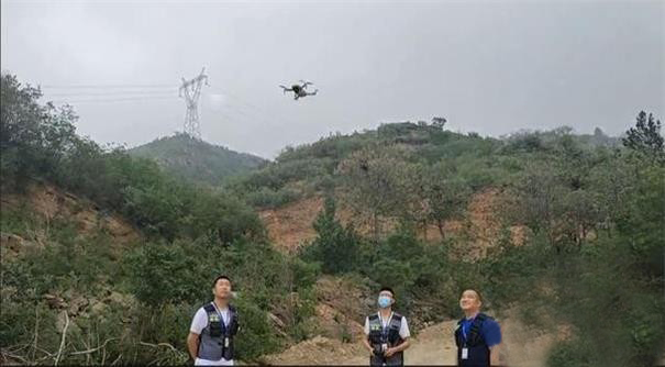
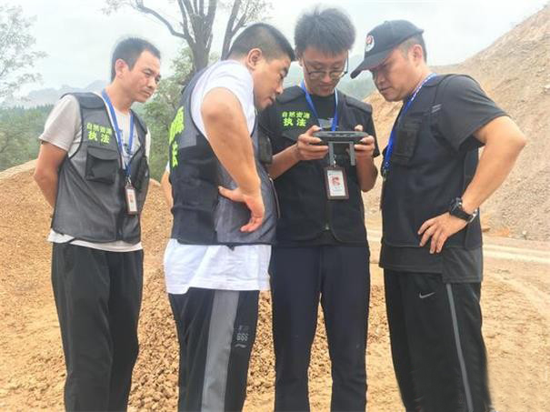
In the past few days, an unmanned aerial vehicle hovered over the mountainous area in the southern part of Gongyi City. Under the operation of the staff, it kept high and low, long and short, and recorded the ground conditions in real time. At the other end, professional staff pre-set the trajectory of the drone flight, including the southern mountainous areas and other key areas into the set trajectory, and use high-resolution cameras to take pictures of key and hidden areas during the flight... This is Gongyi City The staff of the Bureau of Natural Resources and Planning are using drone aerial photography technology to carry out dynamic inspections of natural resources law enforcement to help law enforcement officers monitor management.
In the next step, Gongyi City will give full play to the "third eye" role of drones in natural resource investigations, land satellite film enforcement inspections, and mine inspections to ensure early prevention, early detection, and early investigation and punishment of illegal activities. . In the future, the Law Enforcement and Supervision Brigade of the Gongyi City Resources Planning Bureau will use drones throughout the city to assist the law enforcement and supervision of natural resources and improve the city's natural resources supervision level.
In the past few days, an unmanned aerial vehicle hovered over the mountainous area in the southern part of Gongyi City. Under the operation of the staff, it kept high and low, long and short, and recorded the ground conditions in real time. At the other end, professional staff pre-set the trajectory of the drone flight, including the southern mountainous areas and other key areas into the set trajectory, and use high-resolution cameras to take pictures of key and hidden areas during the flight... This is Gongyi City The staff of the Bureau of Natural Resources and Planning are using drone aerial photography technology to carry out dynamic inspections of natural resources law enforcement to help law enforcement officers monitor management.
According to the staff of the Natural Resources and Planning Bureau of Gongyi City, for a long time, law enforcement supervision tasks have been heavy and regional coverage has been extensive, causing problems such as low detection rate of violations and difficulty in law enforcement. In order to move forward the law enforcement gates and increase inspection efforts, the bureau has innovated the daily inspection work mode, using the advantages of drones such as strong timeliness, good maneuverability, convenience and flexibility, and wide inspection range. The key areas are included in the set trajectory, and the high-resolution cameras are used to shoot the key and hidden areas during the flight to achieve real-time transmission of high-precision images beyond the visual range, and achieve a breakthrough from plane inspection to three-dimensional inspection, and the quality and efficiency of law enforcement Both are greatly improved. At the same time, it effectively made up for the lack of law enforcement power and difficulty in obtaining evidence for illegal activities, and increased the crackdown on illegal land occupation and illegal mining.
In the next step, Gongyi City will give full play to the "third eye" role of drones in natural resource investigations, land satellite film enforcement inspections, and mine inspections to ensure early prevention, early detection, and early investigation and punishment of illegal activities. . In the future, the Law Enforcement and Supervision Brigade of the Gongyi City Resources Planning Bureau will use drones throughout the city to assist the law enforcement and supervision of natural resources and improve the city's natural resources supervision level.

FLYD-100
Wheelbase: 1000MM?? Height: 500MM
Frame Weight: 3.5KGS
Supply voltage: 6S
Motor: U8 KV150
Propeller: 28 inch propeller
Battery: 1 units 16000 mAh 22.2V?
Payload: 1-5KGS
Endurance: 50 minutes(without payload)


Contact: Fly Dragon Drone Tech.
Email: frank at dronefromchina.com
Add: NO. 9 Dayu Road PiDu distric, ChengDu 611730, China