What is Drone Orthophotography and application

What is drone orthomosaic?
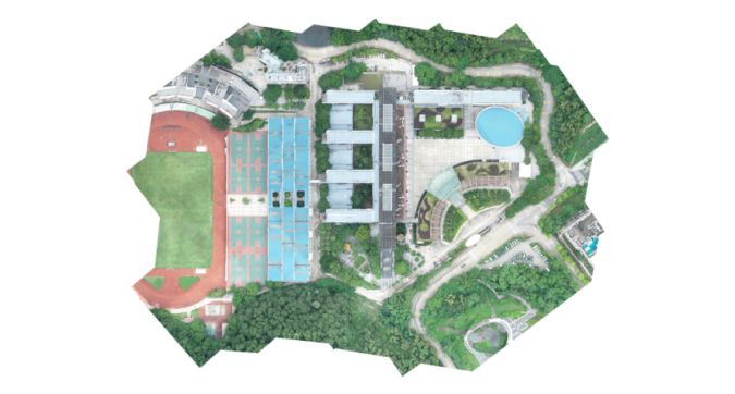
Drone orthomosaic, sometimes called an orthophoto, is a high-resolution aerial imagery captured by a drone. The high-resolution images taken by drones can be stitched together by mapping software to create a 3D map with detailed elevation and distortion-free, providing decision-makers with a basis for making detailed construction plans.
What makes a drone orthophoto different from a standard aerial photo is the way it visualizes perspective. Orthophotos are corrected for perspective, camera tilt, and lens distortion. Doing this means these photos are accurately scaled between images, giving you a measured measure of true distance you can trust.
Convert an orthomosaic to an orthomosaic set
It is important to note that a single orthophoto will appear distorted. Each aerial photo is taken from a slightly different angle, and a single photo is moot. All images must be orthorectified together - accounting for and correcting for different camera angles and terrain variations - to produce a consistent map. One of the easiest ways to ensure this consistency is to use automated drones to develop sensible flight paths.
In addition to using automatic flight paths, you will also need drone mapping software with orthomosaic capabilities, such as DJI Terra. With Terra, you can generate a 2D orthomosaic of a set area in real time. Other Terra features include 3D mapping and reconstruction, lidar processing, and data analysis.
Advantages and disadvantages of drone orthoprojection
Drone orthomosaics have several advantages over conventional aerial photos. Orthographic mosaics are valuable to surveyors because they are undistorted and unaffected by factors such as perspective. They can also easily be turned into interactive 3D results. For jobsites that require scalable maps with consistent detail at all times, the orthomosaic option is simply unrivaled.
Ortho-mosaic mapping does have its drawbacks. The modeling style requires more close-up images and requires you to fly the drone closer to the ground. This may take more time than other methods. Furthermore, sometimes the image detail that is the trademark of orthomosaic mapping is not needed. For example, if you just want to determine the boundaries of a piece of land or just need to image a specific area in detail, then an orthomosaic may offer very little.

Application of Drone Orthomosaic
Agriculture: Taking multiple orthophotos over time allows farmers to spot patterns in how their crops grow over time. This is especially important for monitoring crop health.
Law enforcement: Police and firefighters use drone mapping to map busy areas and crime scenes. With its higher level of detail, ortho maps may be able to capture important details that would otherwise be missed.
Real Estate: Ortho-mosaics of real estate can be turned into interactive virtual tours. This feature was especially important at the height of the COVID-19 pandemic, when in-person property travel was restricted.
Conservation: Conservationists can use orthomosaic photos to spot endangered animals or capture changes over time in set land parameters.
Overall, drone orthophotos and maps are useful for detailed imaging and terrain accuracy. Whether you want to use orthomosaic imaging for land surveying or its applications. Drone positive photography is undoubtedly the most cost-effective measurement method at present.
