TOP 3 drone survey& mapping software
Drone aerial survey software, is software based on aerial surveying, mapping, and modeling, and its functions mainly include aerial survey data acquisition, processing and analysis. A good drone surveying and mapping software can help users to provide work efficiency. Today Feilong will introduce 3 classic drone surveying and mapping software.
Pix4D
In 2011, he started from the EPFL (Switzerland Federal Institute of Technology in Lausanne) Computer Vision Laboratory. With solid technology, he expanded his business to France, the United States and China, and established offices respectively.
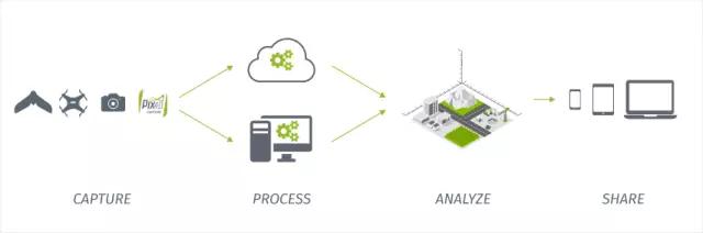
The picture above shows the workflow of Pix4D, so the Pix4D introduced here is actually a complete set of Pix4D series software, including Pix4Dcapture mobile terminal, Pix4D Desktop desktop and Pix4D Cloud cloud. After the complete process, Pix4D can perform volume calculations, contours, 3D point clouds, digital surface models, orthophoto mosaics, 3D texture models, etc.
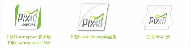
Pix4Dcapture: Free to download and use, similar in function to most route planning software. After connecting the drone, selecting the area (irregular shape can be set) and setting the aerial survey altitude, the drone can automatically perform the task.
Pix4D Desktop: Free download, but the software will set a trial period. The desktop software can process (offline) the data acquired from Pix4Dcapture. The official Windows installation package is provided by default. For macOS users, you can also refer to this link https://pix4d.com.cn/cloud/index.php/s/Z9Dkv76nr99LKM3 to download the beta version.
Pix4D Cloud: bundled with Pix4D Desktop and sold together. The function is that it is used to process the acquired data in the cloud (to avoid the worry of insufficient performance of the local computer), and it is convenient to store and display the shooting data and output the results. In addition to the provision of software tools, Pix4D is also equipped with technical support, community Q&A and other after-sales services. On the whole, this is a typical set of foreign commercial software services. In terms of price, the annual rental price of Pix4Dmapper Professional Edition provided by the official website is 3,500 US dollars (approximately RMB 2,3082.5),
Skycatch
A drone data collection company, located in San Francisco, has raised $22 million in its Series B financing. The early work of Skycatch was to collect high-definition images and video information in the sky. As long as customers specify the data they need to collect on the Skycatch software platform, Skycatch can independently plan how to complete the task and send the data back to the user. The business is mainly concentrated in the construction industry, mining, solar energy and agriculture. In the mining industry, mining companies can track the amount of minerals they have dug in real time, evaluate the quality of raw ore, and conduct real-time analysis of other aspects of data.
Later, they also launched their own aerial survey software package for drone users: Skycatch app: The mobile client is used to connect to drones, so the Skycatch app is the same as the above two, responsible for route planning and data collection. Skycatch dashboard: It also moves the collected data to the web page for operation.
DroneDeploy

DroneDeploy users are scattered in more than 150 countries and have mapped more than 10 million acres of land.
DroneDeploy app: Users can download the client version of DroneDeploy on Google Play or the App Store in the US to plan routes and browse the interactive maps or 3D models that have been built.
DroneDeploy web: There is a 30-day free trial period for users to upload aerial photos for processing. In addition to various surveying and mapping models, you can also choose NDVI, VARI and other algorithms to view the health of crops in the image.
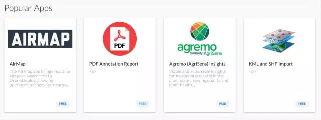
App Market: This is an important feature that distinguishes DroneDeploy from other aerial survey software. Users can download and use the corresponding software (cloud services) in the App Market according to their own scenarios and professional fields, and run them on DroneDeploy, such as using WhiteClouds to 3D print drone maps, EZRoof to inspect the roof of the house, or AgriSens Analysis of crops.
Summary
Dronel survey software usually includes a data collection part based on mobile phones and tablet clients and an image processing part based on web and desktop development. In the data collection part, the core function is still route planning, which has become the standard configuration of the drone survey software. What really differentiates the aerial survey software is in the data processing part. Excellent processing algorithms will output excellent surveying and mapping modeling. The above three softwares are considered to be the best in drone aerial surveys. If you have the conditions, you may wish to try them all.
