Which one is better for mapping, dual lens or five lens for tilt camera?
As an emerging surveying and mapping technology that has been maturely applied, the oblique photography technology has been accepted and used by more and more surveying and mapping people and industry users. The oblique photography technology combined with UAV systems for surveying and mapping is more portable, economical, practical and efficient.
However, once we understand the hardware products of tilt photography, we will find that the lenses of tilt photography cameras are thousands of strange, single lens, double lens, three lens, four lens, five lens, and even nine lens can find related products. The data collection methods of lens cameras are also different. The effects and quality of models made by rotating, swinging, one-exposure, and multi-lens cameras are also uneven.
FlyDragon uses the pros and cons and operating effects of different types of tilt photography hardware products from a variety of perspectives based on our company’s experience and perspective.

Lens performance index
Now consider the hardware indicators of tilt camera cameras are nothing more than the following aspects:
Single camera pixel
The tilt camera is composed of multiple single cameras facing different angles. By collecting image data from different angles, the original texture data of the tilt photography modeling is obtained. The single camera pixel determines the single angle data collection capability of the tilt camera. According to the difference of the single camera used by the tilt camera, the pixel size is also different. From this analysis, the multi-lens camera cannot be horizontally compared. The current main pixel arrangements in the industry are 20.1 million, 24.3 million, 36.4 million, and 42.4 million.
Total camera pixels
Total pixels has always been an indicator of fierce competition among multi-lens camera manufacturers. A five-lens camera calculates the total number of pixels for the five facing cameras. A dual-lens camera determines the total pixels according to the exposure mode. For example, a dual-lens rotating exposure and a group of four shots are calculated according to (single camera pixels*4). , Dual-lens swing exposure, a group of 6 to 8 shots, the total pixels are calculated according to (single camera pixel *6) or (single camera pixel *8).
Frame size
The different frames in the digital age refer to sensors of various sizes. The lenses of the same focal length are used for aerial photography at the same height. The larger the frame, the larger the ground area that can be collected. Tilting cameras with different lens numbers can be selected in frame parameters without the need for horizontal contrast.
Lens focal length
 The focal length of the camera used for aerial surveys of UAVs is generally adjusted to infinity, and the lens has a long focal length to ensure that high-resolution ground images can be obtained even when the UAV is mounted at an altitude of several hundred meters. The focal length of the tilt camera is mostly 10.4mm, 16mm, 25mm, 35mm, 50mm, etc. Generally, fixed focus 25mm, 35mm, 50mm lenses are recommended, which are suitable for tilting aerial surveys in multiple environments and large scenes.
Overall weight
The smaller the number of single cameras of the tilt camera, the lighter the overall weight. Therefore, the dual lens has a certain advantage in weight compared to the five lens.


Single lens aerial survey
In the early stage of the development of oblique photography technology, the camera often adopted the "well"-shaped aerial flight operation method, that is, the lens was oriented at an angle, and then the method of dense flight and cross flight was adopted to collect data. This collection method is inefficient and complex.
Dual lens aerial survey
Whether it is swing shooting or selective shooting, the dual-lens tilt camera has two exposure methods.
First, continuous flight exposure, that is, during the flight route, the drone keeps flying at a constant speed, the camera performs one exposure at the exposure point, and then the second exposure to obtain a set of data. This continuous flight operation method, a set of photos, the interval between two exposures, and the actual exposure location are subject to positioning errors due to the flight speed.
Second, stop the flight exposure, that is, in the flight route, the drone is hovering in the air at the exposure point, and the camera performs a set of exposures before flying to the next exposure point. This approach is obvious and the operation efficiency is low, so it is not recommended .
Third, during dual-lens flight operations, it is easy to cause fluctuations in photo exposure and distortion, which is not conducive to later data processing and correction.
Five-lens aerial survey
The five-lens camera uniformly exposes at one point, and one exposure can obtain photos of five perspectives of front, back, bottom, left, and right. Therefore, the exposure data can be stably obtained on a drone platform that is driving at a stable and uniform speed.
Data processing


From the perspective of the modeling effect, whether it is a swing dual-lens or a rotating dual-lens, its orientation angle lacks a down-view lens. The lack of a down-view lens leads to places like ground objects scenes such as seams between buildings. The lack of original data results in insufficient details and holes in the later modeling process.
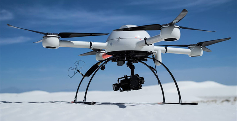
Best drone for mapping& surveying
Specifications:
Wheelbase: 1600mm
Frame Weight: 3.8kg(with landing gear)
RTF Weight: 6.8kg(no battery)
Max. Take-off Weight: 28kg (36kg by using 8120 motor or T-motor P80)
Flight Time: 90 minutes(no payload)(4x 6s 30000mAh Li-ion battery);70 minutes(4x 6s 22000mAh Lipo battery)
Voltage: 48V
Battery: 6S 22000mAh Lipo x4; or 6S 30000mAh Li-ion x4
